Changes
Page history
Update Daily
authored
Apr 07, 2025
by
Peter Hoffmann
Hide whitespace changes
Inline
Side-by-side
home/Daily.md
View page @
503f7e76
# Radar
<sup>
$
`\textcolor{magenta}{\text{DWD}}`
$
</sup>
Radarbild|Radarfilm
---|---

|!
[](
https://www.dwd.de/DWD/wetter/radar/radfilm_brd_akt.gif
)
# Rückblick
Mo|Di|Mi|Do|Fr|Sa|So
---|---|---|---|---|---|---

|!
[](
https://www.dwd.de/DWD/klima/agrar/vd/vd_rr24_di.png
)
|!
[](
https://www.dwd.de/DWD/klima/agrar/vd/vd_rr24_mi.png
)
|!
[](
https://www.dwd.de/DWD/klima/agrar/vd/vd_rr24_do.png
)
|!
[](
https://www.dwd.de/DWD/klima/agrar/vd/vd_rr24_fr.png
)
|!
[](
https://www.dwd.de/DWD/klima/agrar/vd/vd_rr24_sa.png
)
|!
[](
https://www.dwd.de/DWD/klima/agrar/vd/vd_rr24_so.png
)
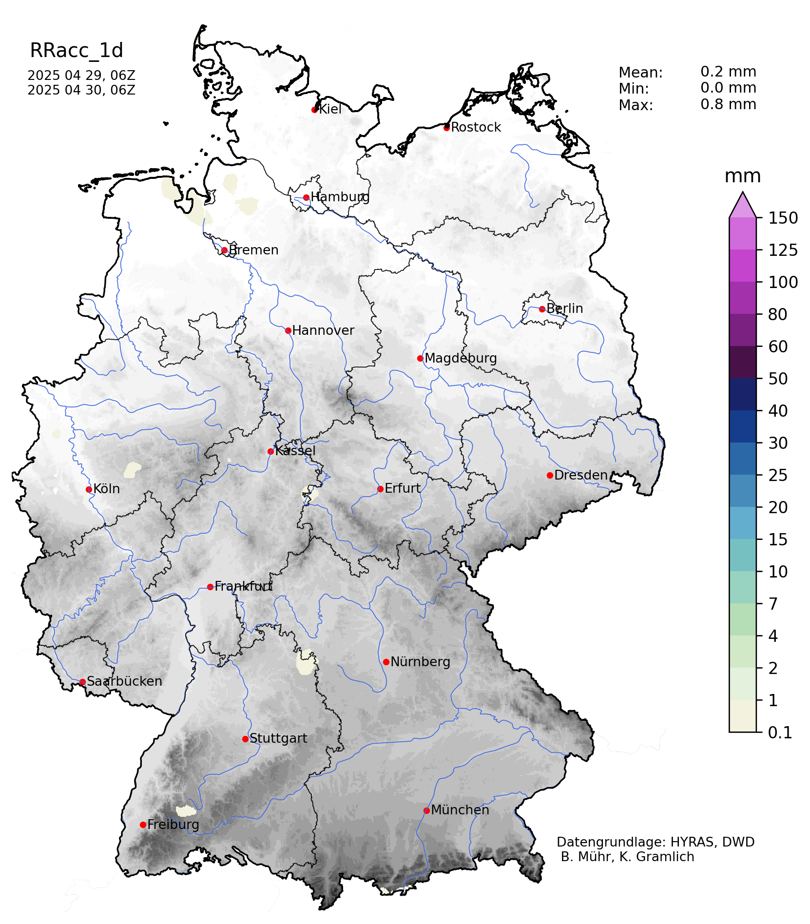
# Regnie
1d|2d|3d|4d|30d|Monat|365d
---|---|---|---|---|---|---
{height=150px}|!
[](
https://www.wettergefahren-fruehwarnung.de/Artikel2/Regnie/regnie48h.png
)
{height=150px}|!
[](
https://www.wettergefahren-fruehwarnung.de/Artikel2/Regnie/regnie72h.png
)
{height=150px}|!
[](
https://www.wettergefahren-fruehwarnung.de/Artikel2/Regnie/regnie96h.png
)
{height=150px}|!
[](
https://www.wettergefahren-fruehwarnung.de/Artikel2/Regnie/regnie720h.png
)
{height=150px}|!
[](
https://www.wettergefahren-fruehwarnung.de/Artikel2/Regnie/regnie_am.png
)
{height=150px}|!
[](
https://www.wettergefahren-fruehwarnung.de/Artikel2/Regnie/regnie365d.png
)
{height=150px}
# Geopotential
<sup>
$
`\textcolor{magenta}{\text{Wetterzentrale}}`
$
</sup>
Analyse|+24h|+48h|+72h
---|---|---|---
|!
[](
http://www1.wetter3.de/Animation_00_UTC/24_27.gif
)
|!
[](
http://www1.wetter3.de/Animation_00_UTC/48_27.gif
)
|!
[](
http://www1.wetter3.de/Animation_00_UTC/72_27.gif
)
**+96h**
|
**+120h**
|
**+144h**
|
**+168h**
|!
[](
http://www1.wetter3.de/Animation_00_UTC/120_27.gif
)
|!
[](
http://www1.wetter3.de/Animation_00_UTC/144_27.gif
)
|!
[](
http://www1.wetter3.de/Animation_00_UTC/168_27.gif
)
# Spaghetti
<sup>
$
`\textcolor{magenta}{\text{Wetterzentrale}}`
$
</sup>
Analyse|+24h|+48h|+72h
---|---|---|---

|!
[](
http://www.wetterzentrale.de/maps/GFSSPAGEU00_24_1.png
)
|!
[](
http://www.wetterzentrale.de/maps/GFSSPAGEU00_48_1.png
)
|!
[](
http://www.wetterzentrale.de/maps/GFSSPAGEU00_72_1.png
)
**+96h**
|
**+120h**
|
**+144h**
|
**+168h**

|!
[](
http://www.wetterzentrale.de/maps/GFSSPAGEU00_120_1.png
)
|!
[](
http://www.wetterzentrale.de/maps/GFSSPAGEU00_144_1.png
)
|!
[](
http://www.wetterzentrale.de/maps/GFSSPAGEU00_168_1.png
)
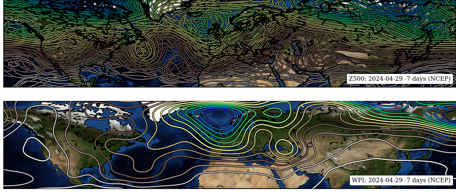
# Similarity
Analyse|Prognose
---|---
|!
[](
http://www.pik-potsdam.de/~peterh/se82/fig/cfs.png
)
# GFSWT
## latest

## forecast

# CFS Kontext Potsdam
Hitze|Starkregen
---|---
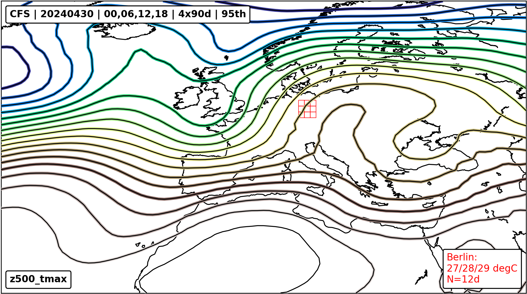
{height=250}|!
[](
http://www.pik-potsdam.de/~peterh/se82/fig/z500_prate.png
)
{height=250}
# Regensummen
<sup>
$
`\textcolor{magenta}{\text{Wetterzentrale}}`
$
</sup>
GFS +144h|WRF +72h
---|---

{height=350px}|!
[](
https://www.wetterzentrale.de/maps/WRFOPGE00_72_18.png
)
{height=350px}
# Phänologie
<sup>
$
`\textcolor{magenta}{\text{DWD}}`
$
</sup>
Deutschland|Sachsen
---|---

|!
[](
https://www.dwd.de/DWD/klima/agrar/phaeno/phaeno_uhr_SN_akt.png
)
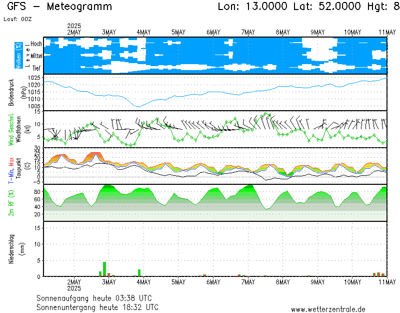
# Berlin
GFS|DWD
---|---

{height=200px}|!
[](
https://www.dwd.de/DWD/wetter/wv_allg/deutschland_trend/bilder/ecmwf_meg_10382.png
)
{height=200px}
{width=100%}
# Dürremonitor
<sup>
$
`\textcolor{magenta}{\text{UFZ}}`
$
</sup>
bis 25cm (akt.)|bis 25cm (30 Tage)|bis ca 1.8m (30 Tage)
---|---|---
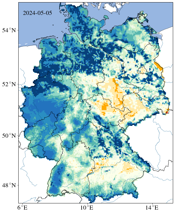
|!
[](
https://files.ufz.de/~drought/SM_L02_aktuell.png
)
|!
[](
https://files.ufz.de/~drought/SM_Lall_aktuell.png
)
# Weiße Elster: Gera
<sup>
$
`\textcolor{magenta}{\text{HNZ-thueringen}}`
$
</sup>
Verlauf|Prognose
---|---
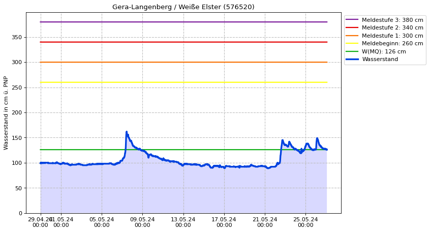
{height=250px}|!
[](
http://hnz.thueringen.de/hw-portal/static/diagramme/wq_prognose/w_576520.png
)
{height=250px}
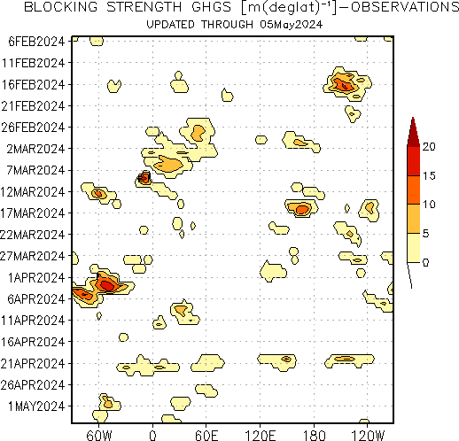
# Blocking Index
<sup>
$
`\textcolor{magenta}{\text{NOAA}}`
$
</sup>
Blocking|60°N-90°N|40°N-60°N|Persistence
---|---|---|---
{height=200px}|!
[](
http://www.cpc.ncep.noaa.gov/products/intraseasonal/500z_tlon_60-90n.gif
)
{height=200px}|!
[](
http://www.cpc.ncep.noaa.gov/products/intraseasonal/500z_tlon_45-60n.gif
)
{height=200px}|!
[](
http://www.pik-potsdam.de/~peterh/se82/fig/hovmuller.png
)
{height=200px}
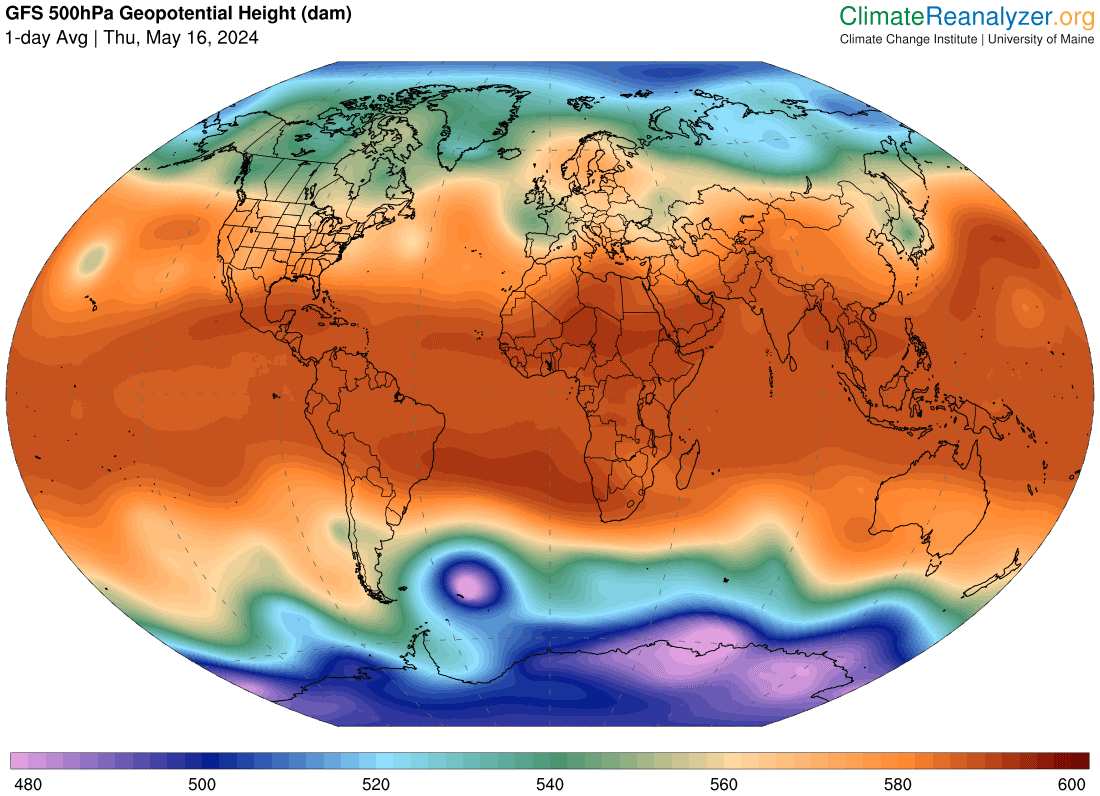
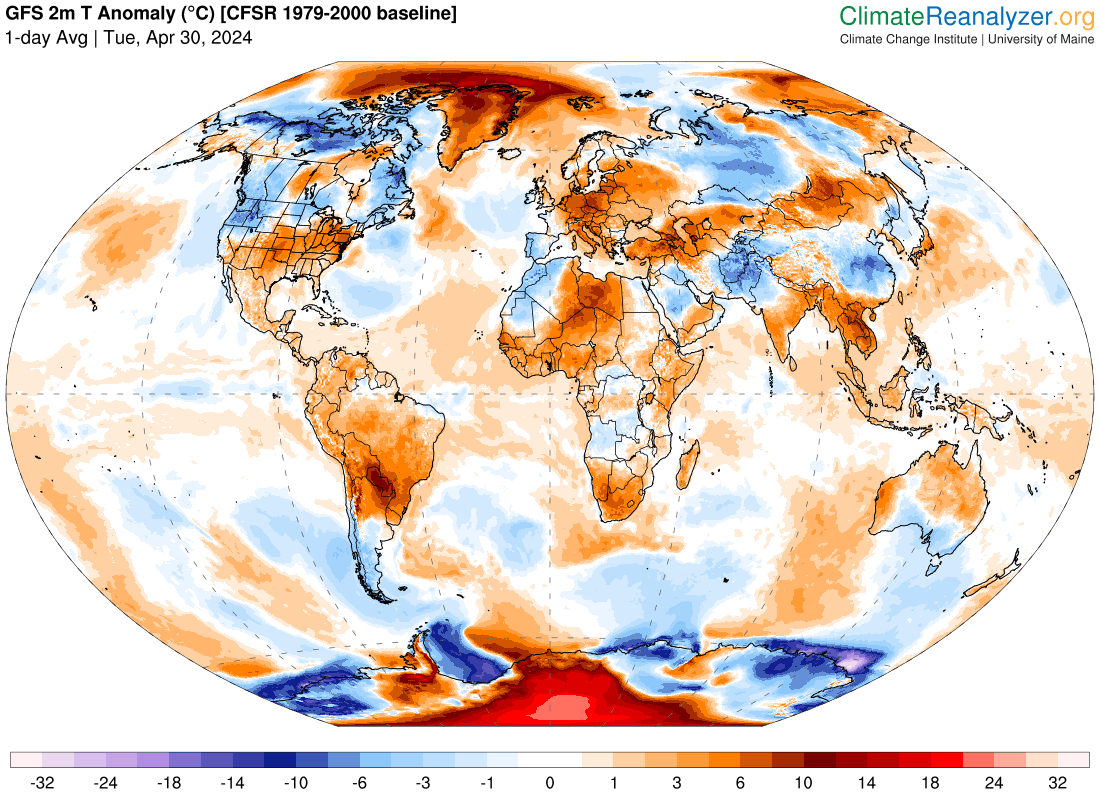
# Reanalyzer
Geopotential|Jet Stream
---|---
{height=300px}|!
[](
https://climatereanalyzer.org/wx/todays-weather/maps/gfs_world-wt_ws250-mslp_d1.png
)
{height=300px}
**Temperaturanomalie**
|
**SST Anomalie**
{height=300px}|!
[](
https://climatereanalyzer.org/wx/todays-weather/maps/gfs_world-wt_sstanom_d1.png
)
{height=300px}
# WebCams
Brocken|Klingenthal
---|---
{height=300px}|!
[](
https://berggasthaus-klingenthal.de/wp-content/uploads/webcam/webcam.jpg
)
{height=300px}
**Oberwiesenthal**
|
**Hohenpeißenberg**
{height=300px}|!
[](
https://www.dwd.de/DWD/wetter/aktuell/deutschland/webcam/wkam1-10962-o.jpg
)
{height=300px}
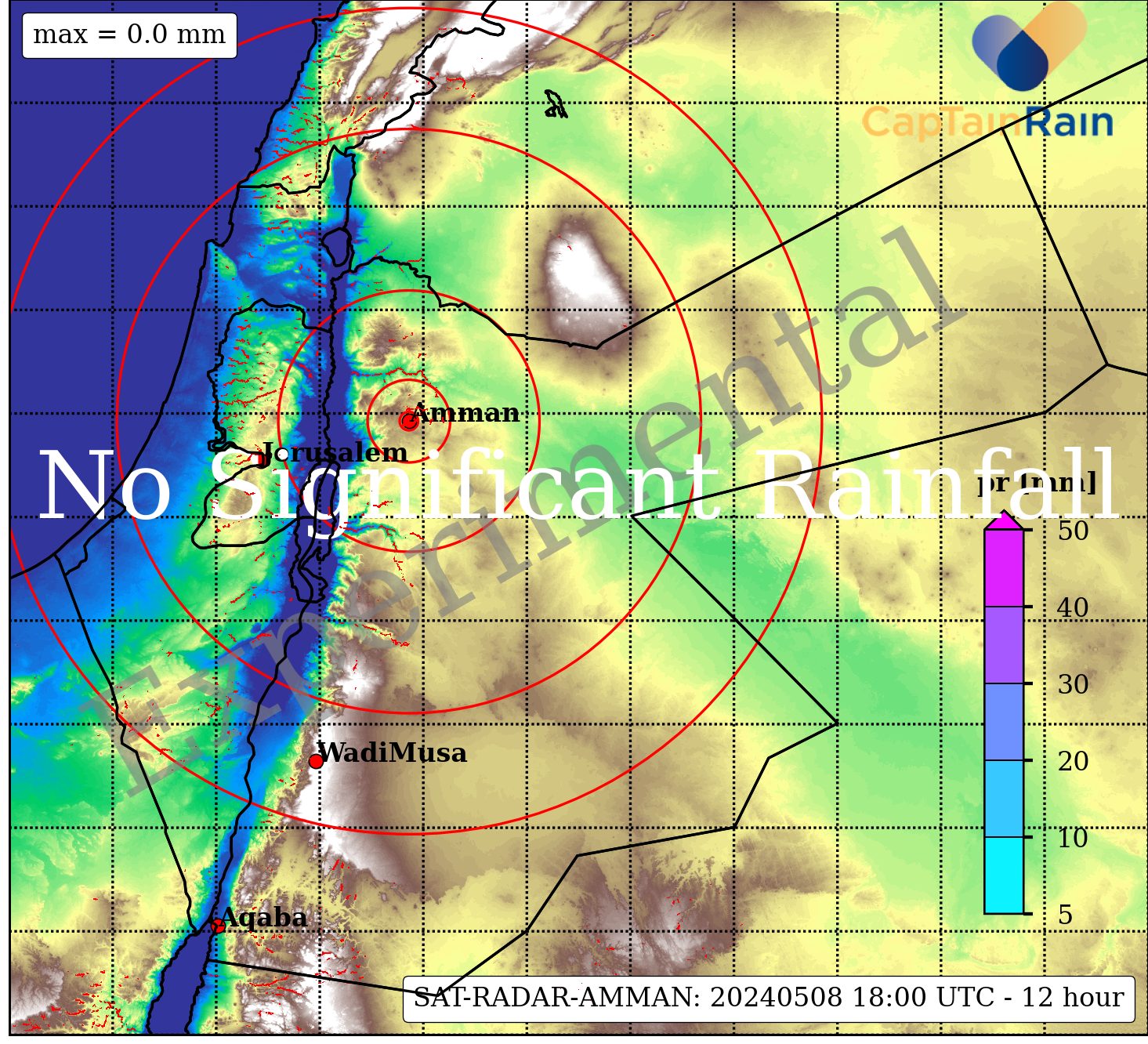
# GSMaP
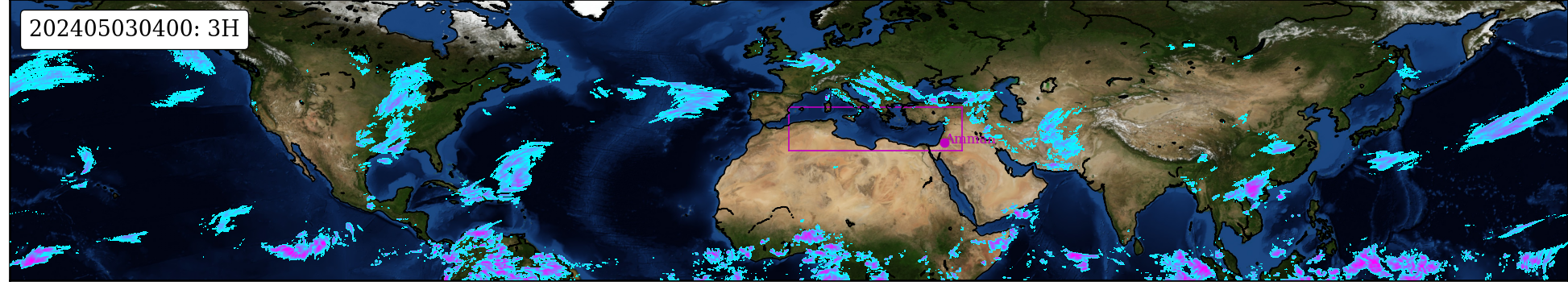
## Jordan
Image|Loop|+24h|+48h|+72h
---|---|---|---|---
{height=150px}|!
[](
http://www.pik-potsdam.de/~peterh/se82/fig/SatRadarJorLoop.gif
)
{height=150px}|!
[](
http://www.pik-potsdam.de/~peterh/se82/fig/GfsRadarJor024.png
)
{height=150px}|!
[](
http://www.pik-potsdam.de/~peterh/se82/fig/GfsRadarJor048.png
)
{height=150px}|!
[](
http://www.pik-potsdam.de/~peterh/se82/fig/GfsRadarJor072.png
)
{height=150px}
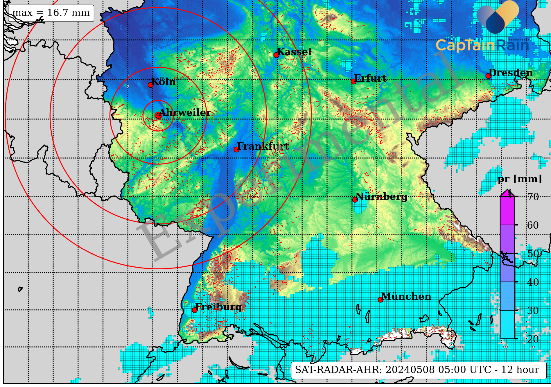
## Germany
Image|Loop|+24h|+48h|+72h
---|---|---|---|---
{height=150px}|!
[](
http://www.pik-potsdam.de/~peterh/se82/fig/SatRadarGerLoop.gif
)
{height=150px}|!
[](
http://www.pik-potsdam.de/~peterh/se82/fig/GfsRadarGer024.png
)
{height=150px}|!
[](
http://www.pik-potsdam.de/~peterh/se82/fig/GfsRadarGer048.png
)
{height=150px}|!
[](
http://www.pik-potsdam.de/~peterh/se82/fig/GfsRadarGer072.png
)
{height=150px}
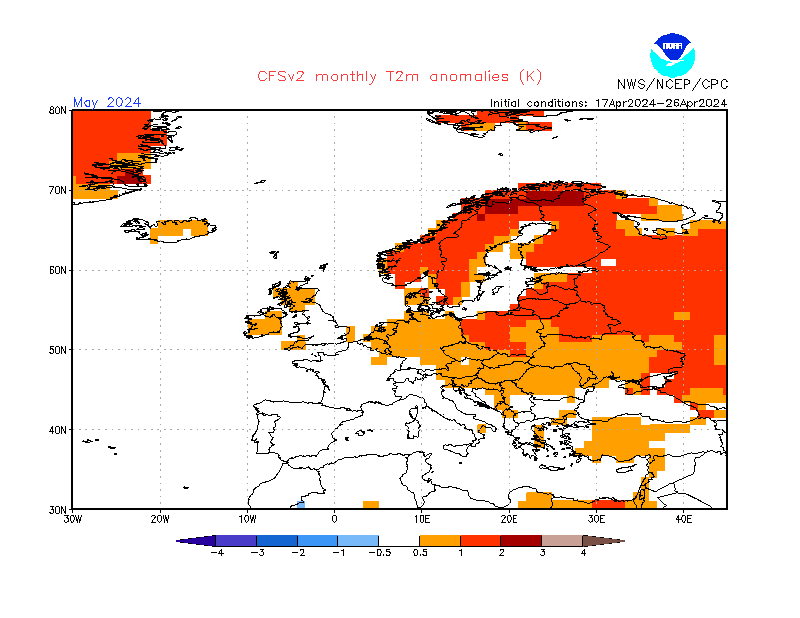
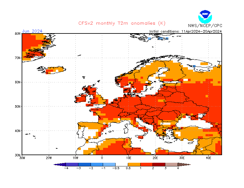
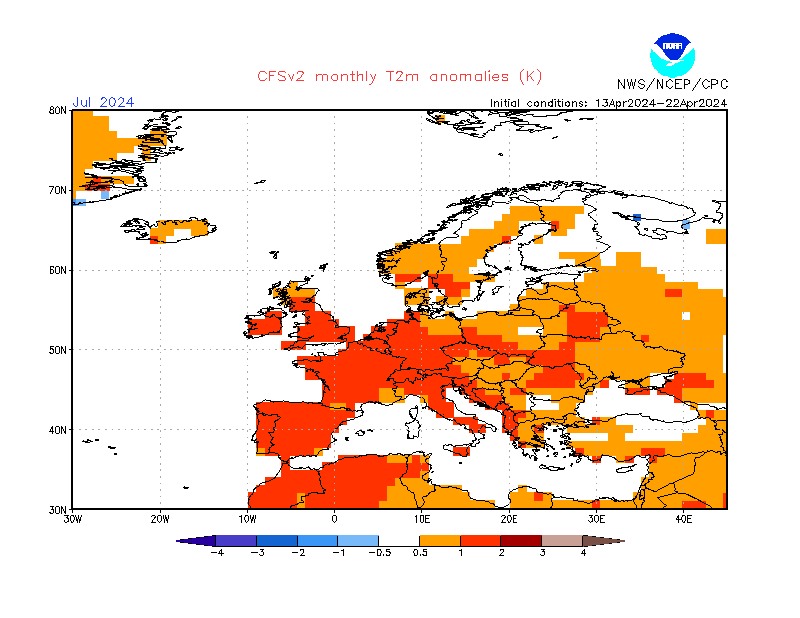
# Climate Forecast System
<sup>
$
`\textcolor{magenta}{\text{NOAA}}`
$
</sup>
Temperatur|Niederschlag
---|---
|!
[](
http://www.cpc.ncep.noaa.gov/products/CFSv2/imagesInd2/euPrecMonInd1.gif
)
|!
[](
http://www.cpc.ncep.noaa.gov/products/CFSv2/imagesInd2/euPrecMonInd2.gif
)
|!
[](
http://www.cpc.ncep.noaa.gov/products/CFSv2/imagesInd2/euPrecMonInd3.gif
)
# Arctic Sea Ice Extent
<sup>
$
`\textcolor{magenta}{\text{Meereisportal}}`
$
</sup>

# QBO Phase
# SatImage
<sup>
$
`\textcolor{magenta}{\text{DWD}}`
$
</sup>
Satellitenbild|Bodendruck
---|---

{height=320px}|!
[](
http://www.dwd.de/DWD/wetter/wv_spez/hobbymet/wetterkarten/bwk_bodendruck_na_ana.png
)
{height=320px}
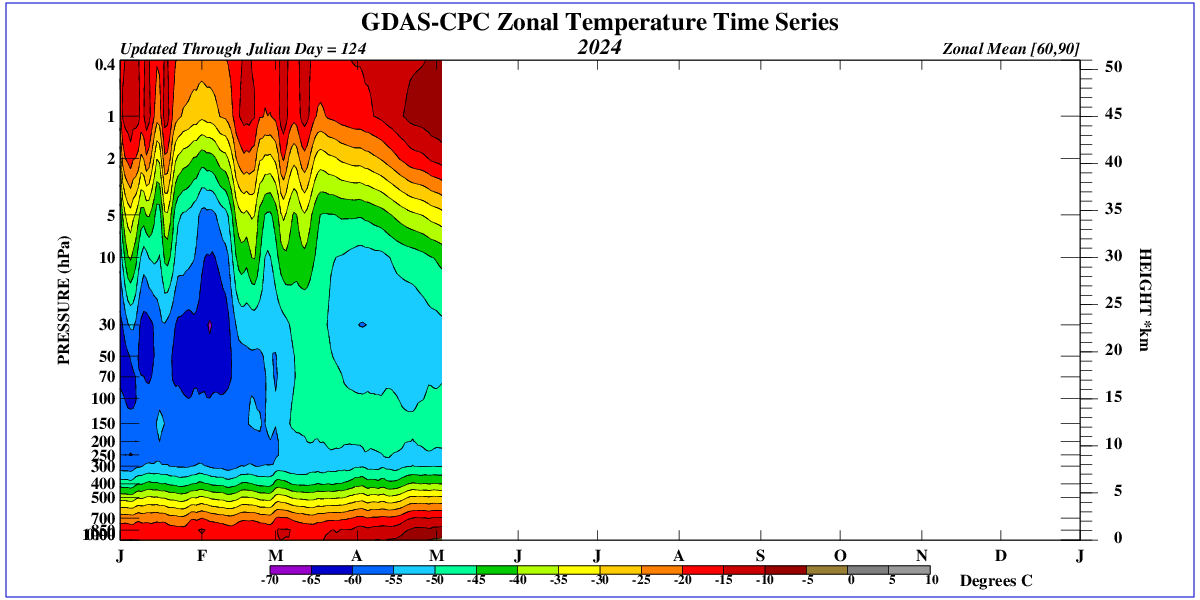
# Stratosphäre - Troposphäre
<sup>
$
`\textcolor{magenta}{\text{NOAA}}`
$
</sup>
# Wirbelstürme
# Radar
<sup>
$
`\textcolor{magenta}{\text{DWD}}`
$
</sup>
Radarbild|Radarfilm
---|---

|!
[](
https://www.dwd.de/DWD/wetter/radar/radfilm_brd_akt.gif
)
# Rückblick
Mo|Di|Mi|Do|Fr|Sa|So
---|---|---|---|---|---|---

|!
[](
https://www.dwd.de/DWD/klima/agrar/vd/vd_rr24_di.png
)
|!
[](
https://www.dwd.de/DWD/klima/agrar/vd/vd_rr24_mi.png
)
|!
[](
https://www.dwd.de/DWD/klima/agrar/vd/vd_rr24_do.png
)
|!
[](
https://www.dwd.de/DWD/klima/agrar/vd/vd_rr24_fr.png
)
|!
[](
https://www.dwd.de/DWD/klima/agrar/vd/vd_rr24_sa.png
)
|!
[](
https://www.dwd.de/DWD/klima/agrar/vd/vd_rr24_so.png
)
# Regnie
1d|2d|3d|4d|30d|Monat|365d
---|---|---|---|---|---|---

{height=150px}|!
[](
https://www.wettergefahren-fruehwarnung.de/Artikel2/Regnie/regnie48h.png
)
{height=150px}|!
[](
https://www.wettergefahren-fruehwarnung.de/Artikel2/Regnie/regnie72h.png
)
{height=150px}|!
[](
https://www.wettergefahren-fruehwarnung.de/Artikel2/Regnie/regnie96h.png
)
{height=150px}|!
[](
https://www.wettergefahren-fruehwarnung.de/Artikel2/Regnie/regnie720h.png
)
{height=150px}|!
[](
https://www.wettergefahren-fruehwarnung.de/Artikel2/Regnie/regnie_am.png
)
{height=150px}|!
[](
https://www.wettergefahren-fruehwarnung.de/Artikel2/Regnie/regnie365d.png
)
{height=150px}
# Geopotential
<sup>
$
`\textcolor{magenta}{\text{Wetterzentrale}}`
$
</sup>
Analyse|+24h|+48h|+72h
---|---|---|---

|!
[](
http://www1.wetter3.de/Animation_00_UTC/24_27.gif
)
|!
[](
http://www1.wetter3.de/Animation_00_UTC/48_27.gif
)
|!
[](
http://www1.wetter3.de/Animation_00_UTC/72_27.gif
)
**+96h**
|
**+120h**
|
**+144h**
|
**+168h**

|!
[](
http://www1.wetter3.de/Animation_00_UTC/120_27.gif
)
|!
[](
http://www1.wetter3.de/Animation_00_UTC/144_27.gif
)
|!
[](
http://www1.wetter3.de/Animation_00_UTC/168_27.gif
)
# Spaghetti
<sup>
$
`\textcolor{magenta}{\text{Wetterzentrale}}`
$
</sup>
Analyse|+24h|+48h|+72h
---|---|---|---

|!
[](
http://www.wetterzentrale.de/maps/GFSSPAGEU00_24_1.png
)
|!
[](
http://www.wetterzentrale.de/maps/GFSSPAGEU00_48_1.png
)
|!
[](
http://www.wetterzentrale.de/maps/GFSSPAGEU00_72_1.png
)
**+96h**
|
**+120h**
|
**+144h**
|
**+168h**

|!
[](
http://www.wetterzentrale.de/maps/GFSSPAGEU00_120_1.png
)
|!
[](
http://www.wetterzentrale.de/maps/GFSSPAGEU00_144_1.png
)
|!
[](
http://www.wetterzentrale.de/maps/GFSSPAGEU00_168_1.png
)
# Similarity
Analyse|Prognose
---|---

|!
[](
http://www.pik-potsdam.de/~peterh/se82/fig/cfs.png
)
# GFSWT
## latest

## forecast

# CFS Kontext Potsdam
Hitze|Starkregen
---|---

{height=250}|!
[](
http://www.pik-potsdam.de/~peterh/se82/fig/z500_prate.png
)
{height=250}
# Regensummen
<sup>
$
`\textcolor{magenta}{\text{Wetterzentrale}}`
$
</sup>
GFS +144h|WRF +72h
---|---

{height=350px}|!
[](
https://www.wetterzentrale.de/maps/WRFOPGE00_72_18.png
)
{height=350px}
# Phänologie
<sup>
$
`\textcolor{magenta}{\text{DWD}}`
$
</sup>
Deutschland|Sachsen
---|---

|!
[](
https://www.dwd.de/DWD/klima/agrar/phaeno/phaeno_uhr_SN_akt.png
)
# Berlin
GFS|DWD
---|---

{height=200px}|!
[](
https://www.dwd.de/DWD/wetter/wv_allg/deutschland_trend/bilder/ecmwf_meg_10382.png
)
{height=200px}

{width=100%}
# Dürremonitor
<sup>
$
`\textcolor{magenta}{\text{UFZ}}`
$
</sup>
bis 25cm (akt.)|bis 25cm (30 Tage)|bis ca 1.8m (30 Tage)
---|---|---

|!
[](
https://files.ufz.de/~drought/SM_L02_aktuell.png
)
|!
[](
https://files.ufz.de/~drought/SM_Lall_aktuell.png
)
# Weiße Elster: Gera
<sup>
$
`\textcolor{magenta}{\text{HNZ-thueringen}}`
$
</sup>
Verlauf|Prognose
---|---

{height=250px}|!
[](
http://hnz.thueringen.de/hw-portal/static/diagramme/wq_prognose/w_576520.png
)
{height=250px}
# Blocking Index
<sup>
$
`\textcolor{magenta}{\text{NOAA}}`
$
</sup>
Blocking|60°N-90°N|40°N-60°N|Persistence
---|---|---|---

{height=200px}|!
[](
http://www.cpc.ncep.noaa.gov/products/intraseasonal/500z_tlon_60-90n.gif
)
{height=200px}|!
[](
http://www.cpc.ncep.noaa.gov/products/intraseasonal/500z_tlon_45-60n.gif
)
{height=200px}|!
[](
http://www.pik-potsdam.de/~peterh/se82/fig/hovmuller.png
)
{height=200px}
# Reanalyzer
Geopotential|Jet Stream
---|---

{height=300px}|!
[](
https://climatereanalyzer.org/wx/todays-weather/maps/gfs_world-wt_ws250-mslp_d1.png
)
{height=300px}
**Temperaturanomalie**
|
**SST Anomalie**

{height=300px}|!
[](
https://climatereanalyzer.org/wx/todays-weather/maps/gfs_world-wt_sstanom_d1.png
)
{height=300px}
# WebCams
Brocken|Klingenthal
---|---

{height=300px}|!
[](
https://berggasthaus-klingenthal.de/wp-content/uploads/webcam/webcam.jpg
)
{height=300px}
**Oberwiesenthal**
|
**Hohenpeißenberg**

{height=300px}|!
[](
https://www.dwd.de/DWD/wetter/aktuell/deutschland/webcam/wkam1-10962-o.jpg
)
{height=300px}
# GSMaP

## Jordan
Image|Loop|+24h|+48h|+72h
---|---|---|---|---

{height=150px}|!
[](
http://www.pik-potsdam.de/~peterh/se82/fig/SatRadarJorLoop.gif
)
{height=150px}|!
[](
http://www.pik-potsdam.de/~peterh/se82/fig/GfsRadarJor024.png
)
{height=150px}|!
[](
http://www.pik-potsdam.de/~peterh/se82/fig/GfsRadarJor048.png
)
{height=150px}|!
[](
http://www.pik-potsdam.de/~peterh/se82/fig/GfsRadarJor072.png
)
{height=150px}
## Germany
Image|Loop|+24h|+48h|+72h
---|---|---|---|---

{height=150px}|!
[](
http://www.pik-potsdam.de/~peterh/se82/fig/SatRadarGerLoop.gif
)
{height=150px}|!
[](
http://www.pik-potsdam.de/~peterh/se82/fig/GfsRadarGer024.png
)
{height=150px}|!
[](
http://www.pik-potsdam.de/~peterh/se82/fig/GfsRadarGer048.png
)
{height=150px}|!
[](
http://www.pik-potsdam.de/~peterh/se82/fig/GfsRadarGer072.png
)
{height=150px}
# Climate Forecast System
<sup>
$
`\textcolor{magenta}{\text{NOAA}}`
$
</sup>
Temperatur|Niederschlag
---|---

|!
[](
http://www.cpc.ncep.noaa.gov/products/CFSv2/imagesInd2/euPrecMonInd1.gif
)

|!
[](
http://www.cpc.ncep.noaa.gov/products/CFSv2/imagesInd2/euPrecMonInd2.gif
)

|!
[](
http://www.cpc.ncep.noaa.gov/products/CFSv2/imagesInd2/euPrecMonInd3.gif
)
# Arctic Sea Ice Extent
<sup>
$
`\textcolor{magenta}{\text{Meereisportal}}`
$
</sup>

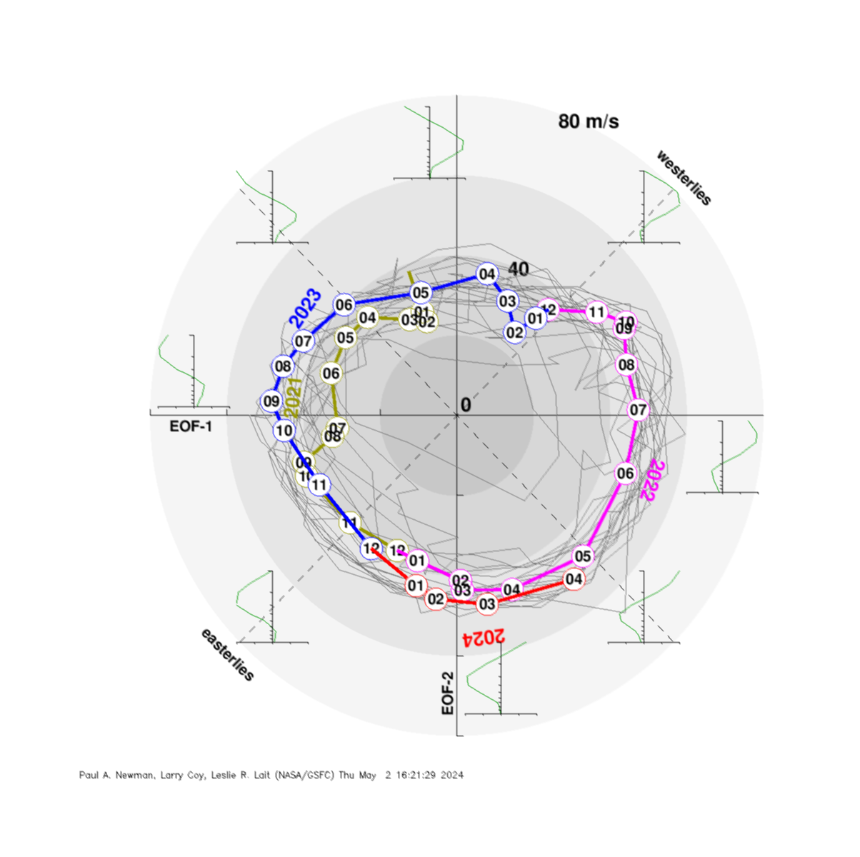
# QBO Phase

# SatImage
<sup>
$
`\textcolor{magenta}{\text{DWD}}`
$
</sup>
Satellitenbild|Bodendruck
---|---

{height=320px}|!
[](
http://www.dwd.de/DWD/wetter/wv_spez/hobbymet/wetterkarten/bwk_bodendruck_na_ana.png
)
{height=320px}
# Stratosphäre - Troposphäre
<sup>
$
`\textcolor{magenta}{\text{NOAA}}`
$
</sup>

# Wirbelstürme
{width=100%}
\ No newline at end of file